Bathymetric surveys are a crucial tool for homeowners with waterfront property. If you’ve ever wondered about the secrets hidden beneath the surface of your lake or pond, this is your guide to unlocking the mysteries of underwater topography. In this article, we’ll dive deep into the details of bathymetric surveys, exploring how they benefit property owners in understanding, managing, and optimizing their water management systems. Whether you’re contemplating shoreline stabilization, considering dredging, or simply curious about what lies beneath, join us as we detail the importance of bathymetric surveys.
A bathymetric survey of a lake or pond is like giving the water body a detailed health check-up, but instead of stethoscopes and thermometers, it involves some advanced tools and techniques. Here’s a breakdown of what goes into this underwater examination:
- Dipping into Depths:
Measuring how deep the water goes is at the heart of a bathymetric survey. Imagine using special underwater “echo” devices that send out sound signals. These signals bounce off the lake or pond bed and return, telling us exactly how far down the bottom is. These depth measurements are the foundation of the survey.
- Navigating the Waters:
Just like GPS helps us find our way on land, it’s a game-changer in the water too. Global Positioning System (GPS) technology helps precisely locate each measurement point. Combining depth with location information creates a detailed map of the water body.
- Crafting the Map:
Bathymetric surveys don’t happen haphazardly. They follow a strategic grid pattern or specific paths across the water. This systematic data collection is like creating a puzzle. The collected data is then processed using specialized software, fitting all the puzzle pieces together to reveal the underwater landscape.
- Drawing the Lines:
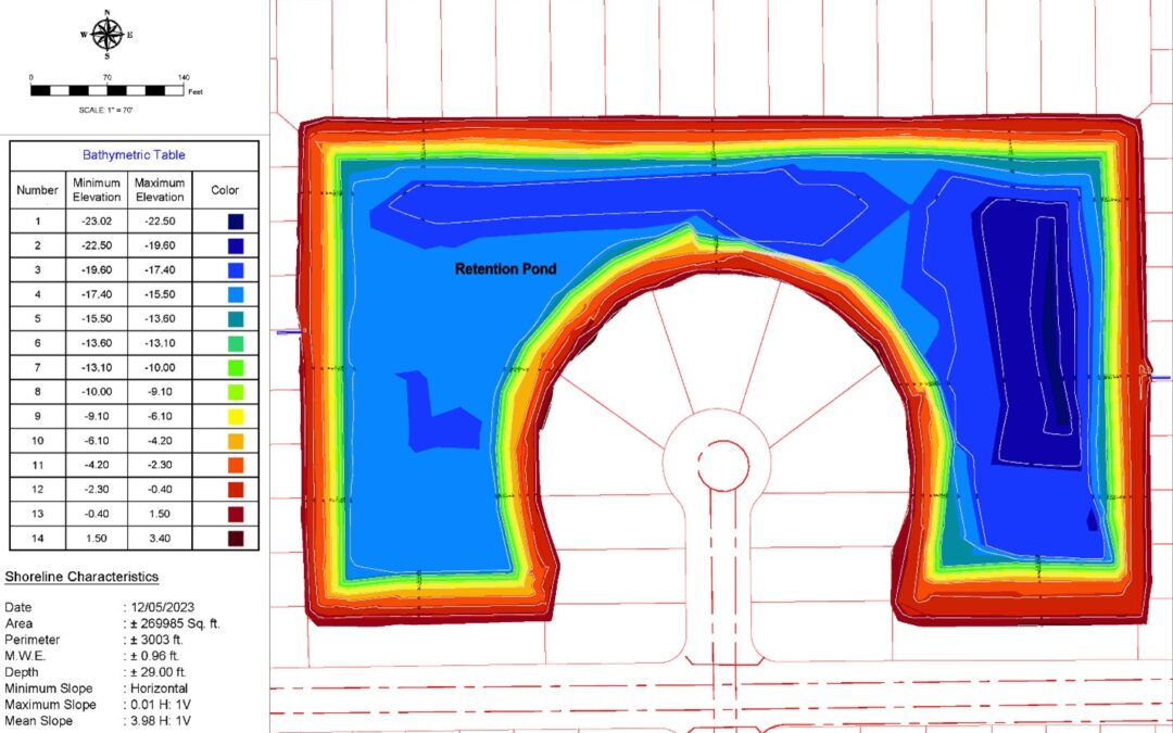
Contour lines are like the water body’s fingerprint. They show us the shape and slopes beneath the surface. Picture these lines as underwater hills and valleys, providing a visual representation of the lake or pond’s topography.
- Calculating the Volume:
It’s not just about how deep the lake is; it’s also about how much water it holds. Bathymetric surveys help calculate the volume of the water body accurately. By comparing data before and after the survey, we can track changes in volume. This is particularly handy for keeping an eye on sedimentation, erosion, or if some dredging might be needed.
- Planning for Dredging:
Dredging is like a spa day for the lake. It involves removing sediment, debris, or unwanted materials from the bottom. Bathymetric surveys provide a detailed roadmap for planners, showing precisely where sediments have settled. This information is gold for dredging operations, ensuring they target the right areas and maintain the water body’s ecological balance.
**Golf Courses**: Consider giving that silty pond a fresh overhaul! Landshore is here to help!
- Shoring Up Stability:
Just like a well-built foundation keeps a house steady, a stable shoreline is crucial for a healthy water body. Bathymetric surveys offer insights into the underwater slopes and features, guiding engineers in crafting effective shoreline stabilization plans. Whether it’s adding protective structures or routine maintenance, understanding the underwater landscape is key to keeping the shoreline resilient against erosion and maintaining its ecological balance.
The Takeaway:
Bathymetric surveys are like underwater detectives, revealing the secrets hidden beneath the lake or pond’s surface. They’re not just about numbers; they’re about understanding the water body’s structure, planning for its future, and ensuring its health for the long haul. Whether it’s for steering boats safely, predicting floods, dredging operations, or safeguarding aquatic life, the data from these surveys is a treasure trove for managing our water resources effectively.
If you have any questions or concerns about your waterfront, we encourage you to reach out to Landshore. Our team of experts is ready to review your specific challenges and assist you in finding the best possible solutions. For more valuable insights and updates from our engineering team, be sure to follow us on our social media channels listed below. We look forward to connecting with you and helping you alleviate your drainage, erosion and sedimentation problems for your property.